


Satellite Technologies
Satellite Technologies
Our Services


Geodetic Design, Production and Terrestrial Measurements
We provide services with our robust and alternative solutions in the production of C Degree networks in strip-like or areal areas, Precision Leveling and RS productions. As UTEK, geodetic deformation, monitoring and tracking are carried out in large areas with InSAR and SAR methods. At the same time, we provide services of precise survey measurements, plancote production, terrestrial lidar, deformation measurements and bathymetry measurements with terrestrial techniques.
Aerial Lidar, Photogrammetry and Base Map
With our unrivaled and state-of-the-art equipment, we have carried out works with photogrammetric, air lidar and thermal imaging systems on tens of thousands of hectares of land and various topographies (Forest, Highway, Railway, ENH, Wind Power Plants, etc.) and successfully delivered our work.


Smart Cities, Building Information Modeling, 3D Building Modeling
We produce effective and sensitive products in data production and management of Smart City, Building Information Modeling and 3D Building Modeling. In addition to Terrestrial Lidar, Mobile Lidar, Mobile Lidar techniques, we are effective in InSAR and SAR satellite data analysis, photogrammetry and all methods of remote sensing. At the same time, we can use our data in the most effective way with terrestrial measurements and software production.
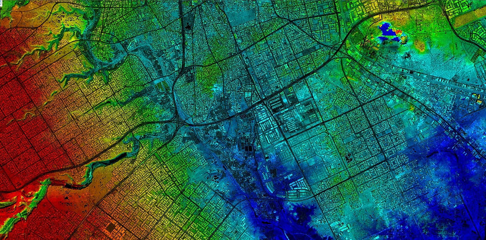
Data Collection, Processing, Analysis and Publication
Data is collected with precise coordinates using MX7, Mobile Laser Scanning, Airborne LIDAR, InSAR and SAR data, Terrestrial Laser Scanning and Handheld Laser Scanning systems, and the data is interpreted, processed, analyzed and published on a WEB basis upon request.
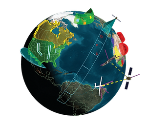
GIS and Satellite Technology
All GIS data are collected and evaluated regardless of the terrain conditions. These data are analyzed at usable levels and processed into the GIS base, ensuring that the desired data can be accessed accurately and quickly at the desired time.
About Us
Mission
Through cutting-edge technology and our expert team, we deliver accurate and up-to-date spatial data to make our clients’ projects safer, more efficient, and more sustainable. By offering innovative solutions in geodesy, GIS, LiDAR, photogrammetry, BIM, and data analytics, we create lasting value for society, the environment, and the economy.
Vision
To become a globally recognized leader in advanced geospatial technologies and integrated engineering approaches, developing smart cities, sustainable infrastructures, and data-driven solutions for future generations.
Values
-
Reliability and Accuracy
-
We are committed to providing the most precise data in all our projects, ensuring reliable outcomes.
-
In sectors where precision is paramount, our quality measurements and analyses set us apart.
-
-
Innovation and Continuous Improvement
-
We believe that creative ideas and new approaches bring added value to both our team and our partners.
-
We closely follow technological advancements and invest in research and development.
-
-
Sustainability and Environmental Awareness
-
We recognize our responsibility to leave a livable world for future generations.
-
Our solutions prioritize energy and resource efficiency, ensuring minimal environmental impact.
-
-
Team Spirit and Collaboration
-
Our multidisciplinary specialists work cohesively, creating an environment that fosters integration and synergy.
-
Strong communication with clients and stakeholders forms the basis of our shared success.
-
-
Customer-Centric Approach
-
We thoroughly analyze each customer’s needs and tailor our projects accordingly.
-
We maintain an optimal balance between time, cost, and quality, aiming for high satisfaction.
-
-
Quality and Professionalism
-
We adhere to national and international standards, applying rigorous project management processes at every stage.
-
From concept to delivery, we focus on every detail to achieve flawless results.
-
-
Ethics and Transparency
-
We uphold integrity in project execution and stakeholder communication.
-
Open communication and accountability define our corporate culture, ensuring trust and credibility.
-
2000
Founded in
114
Project Completed
40
Our Reference Number
Why Us?
Our References


Our Business Partners


Communication
Contact us:
Office
Career
If you would like to work with us, please contact us.